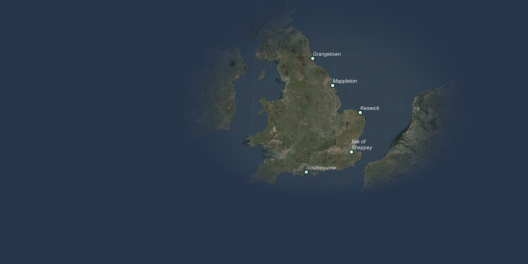
The Rising Risks to Coastal Property and Land
This interactive story map has been developed by Terrafirma to help raise awareness of the devastating impact of coastal hazards as they become more severe across England and Wales. Many coastal towns and communities represent a battleground between land and sea, and it is vital to now recognise the scale of natural disaster the UK will face in the coming decades.
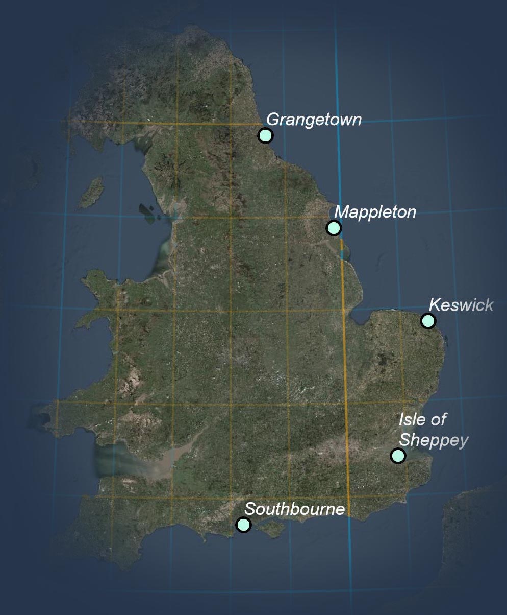
The story map details five key coastal locations that are on the frontline of this battle, and without significant intervention, face the threat of substantial coastal retreat, putting coastal properties and land at risk. As part of our research, Terrafirma have uncovered, as a worst-case scenario, approx. 31,000 properties and approx. 21,000 acres of land are at risk over the next 100 years from coastal retreat. This is at 95% confidence, assuming that there is No Active Intervention to manage the coast.
Imagery: Esri, Maxar, Earthstar Geographics, CNES/Airbus DS, USDA, USGS, AeroGRID, IGN, and the GIS User Community
The Rising Risks to Coastal Property and Land
The story map details five key coastal locations that are on the frontline of this battle, and without significant intervention, face the threat of substantial coastal retreat, putting coastal properties and land at risk. As part of our research, Terrafirma have uncovered, as a worst-case scenario, approx. 31,000 properties and approx. 21,000 acres of land are at risk over the next 100 years from coastal retreat. This is at 95% confidence, assuming that there is No Active Intervention to manage the coast.
Imagery: Esri, Maxar, Earthstar Geographics, CNES/Airbus DS, USDA, USGS, AeroGRID, IGN, and the GIS User Community
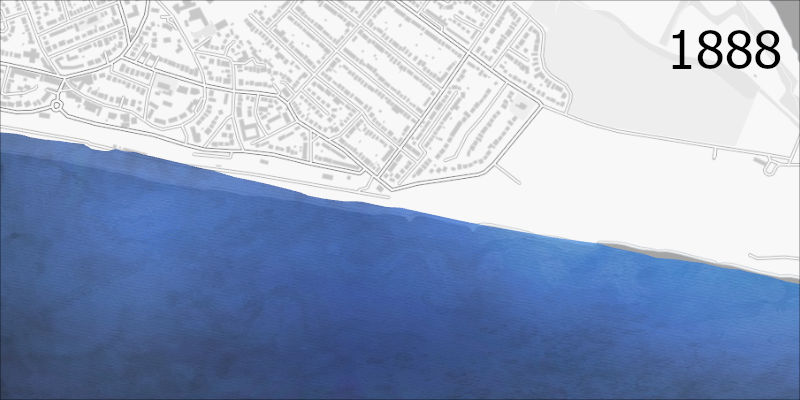
1888 |
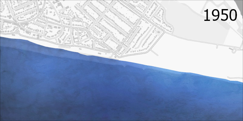
1950 |
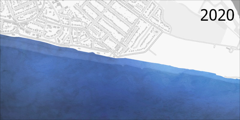
2020 |
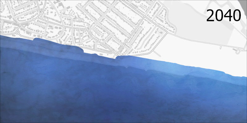
2040 |
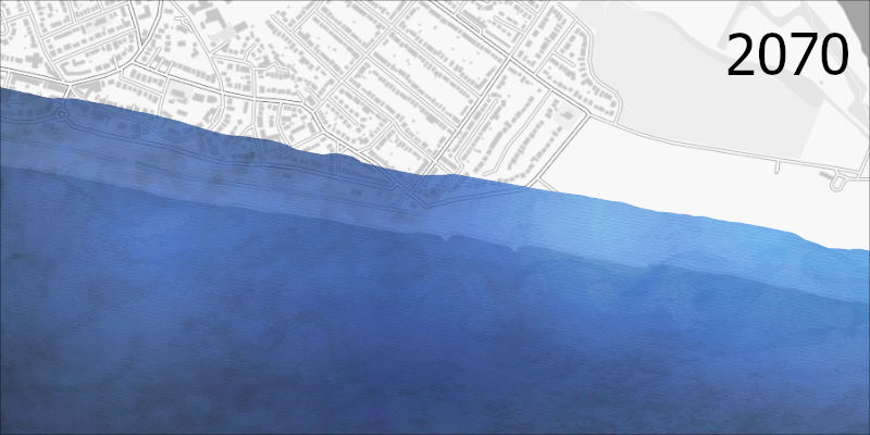
2070
Southbourne - West Sussex
Southbourne is a suburb of the City of Bournemouth on the South Coast of England. With a population of 18,000 and its golden beaches, it is an attractive place to live and leisure. Whilst beautiful, the sandy geology of Southbourne is at high risk from coastal erosion, so sea wall defences hold the line in order to protect the local community. However, as the climate changes and as several recent landslides illustrate, in a worst-case scenario, the shores here may retreat up to 200 metres putting over 1500 properties at risk of collapse in the next 100 years.
(2040/2070 scenes show worst-case scenario)
Contains OS data © Crown copyright and database right 2020
1888 |
1950 |
2020 |
2040 |
2070
Isle of Sheppey - Kent
The Isle of Sheppey sits 40 miles east of London in the county of Kent surrounded by the cool waters of the North Sea. Each winter the soft clays, silts and sands that make up the coastline of Sheppey are exposed to the full wrath of North Sea storms and there are often violent and massive landslides. One such landslide in June 2020 caused a property, worth £200,000 to collapse and several others to be evacuated. As the climate changes and sea levels rise, the unprotected northern coastline of Sheppey is likely to regress by over 100 metres in a worst-case scenario.
(2040/2070 scenes show worst-case scenario)
Contains OS data © Crown copyright and database right 2020
1888 |
1950 |
2020 |
2040 |
2070
Keswick - Norwick
Keswick, part of the village of Bacton, is found on the low-lying glacial sands of the north Norfolk coast. The coastline here is changing here almost weekly, battered by the North Seas winter storms and with almost perpetual erosion of the sandy cliffs. Despite managed realignment and sea wall defences, a best case scenario is over 50 metres of erosion at Keswick in just the next 50 years, threatening the 1900 people that live in the village. A worst-case scenario if the shoreline management plan changes or the defences fail and are not maintained is erosion on the scale of 250 metres over the coming century.
(2040/2070 scenes show worst-case scenario)
Contains OS data © Crown copyright and database right 2020
1888 |
1950 |
2020 |
2040 |
2070
Mappleton - York
The village of Mappleton on the Holderness coastline is a battleground between land and sea. The fastest eroding coastline in Europe had been losing between 5 and 10 metres of land every year until new sea defences were introduced in the 1990s. Although these defences have slowed erosion in the village centre, immediately south, several metres of glacial sands are being lost annually and if the defences fail or if there is no active intervention, by 2100, only 10% of the village of Mappleton will be left standing, with the rest lost to the sea.
(2040/2070 scenes show worst-case scenario)
Contains OS data © Crown copyright and database right 2020
1888 |
1970 |
2020 |
2040 |
2070
Grangetown - Northumberland
Grangetown, situated 2 miles east of Sunderland City centre straddles the Tyne and Wear coastline and includes over 3000 properties. The local geology of dolostone (a type of limestone) is particularly vulnerable to the violent storms of the North Sea and several landslides have occured in recent years along this stretch of coastline. Many parts of the coast here are not protected by sea defences and up to 50 metres of erosion is considered likely over the next 50 years, equating to a metre of land lost every single year. In a worst-case scenario, almost 300 metres of coastline will be lost to the sea, including the recently built Sunderland City ring-road!
(2040/2070 scenes show worst-case scenario)
Contains OS data © Crown copyright and database right 2020
Coast
The Rising Risks to Coastal Property and Land
The story map details five key coastal locations that are on the frontline of this battle, and without significant intervention, face the threat of substantial coastal retreat, putting coastal properties and land at risk. As part of our research, Terrafirma have uncovered, as a worst-case scenario, approx. 31,000 properties and approx. 21,000 acres of land are at risk over the next 100 years from coastal retreat. This is at 95% confidence, assuming that there is No Active Intervention to manage the coast.
Imagery: Esri, Maxar, Earthstar Geographics, CNES/Airbus DS, USDA, USGS, AeroGRID, IGN, and the GIS User Community
Southbourne is a suburb of the City of Bournemouth on the South Coast of England. With a population of 18,000 and its golden beaches, it is an attractive place to live and leisure. Whilst beautiful, the sandy geology of Southbourne is at high risk from coastal erosion, so sea wall defences hold the line in order to protect the local community. However, as the climate changes and as several recent landslides illustrate, in a worst case scenario, the shores here may retreat up to 200 metres putting over 1500 properties at risk of collapse in the next 100 years.
(2040/2070 scenes show worst-case scenario)
Contains OS data © Crown copyright and database right 2020
The Isle of Sheppey sits 40 miles east of London in the county of Kent surrounded by the cool waters of the North Sea. Each winter the soft clays, silts and sands that make up the coastline of Sheppey are exposed to the full wrath of North Sea storms and there are often violent and massive landslides. One such landslide in June 2020 caused a property, worth £200,000 to collapse and several others to be evacuated. As the climate changes and sea levels rise, the unprotected northern coastline of Sheppey is likely to regress by over 100 metres in a worst case scenario.
(2040/2070 scenes show worst-case scenario)
Contains OS data © Crown copyright and database right 2020
Keswick, part of the village of Bacton, is found on the low-lying glacial sands of the north Norfolk coast. The coastline here is changing here almost weekly, battered by the North Seas winter storms and with almost perpetual erosion of the sandy cliffs. Despite managed realignment and sea wall defences, a best case scenario is over 50 metres of erosion at Keswick in just the next 50 years, threatening the 1900 people that live in the village. A worst case scenario if the shoreline management plan changes or the defences fail and are not maintained is erosion on the scale of 250 metres over the coming century.
(2040/2070 scenes show worst-case scenario)
Contains OS data © Crown copyright and database right 2020
The village of Mappleton on the Holderness coastline is a battleground between land and sea. The fastest eroding coastline in Europe had been losing between 5 and 10 metres of land every year until new sea defences were introduced in the 1990s. Although these defences have slowed erosion in the village centre, immediately south, several metres of glacial sands are being lost annually and if the defences fail or if there is no active intervention, by 2100, only 10% of the village of Mappleton will be left standing, with the rest lost to the sea.
(2040/2070 scenes show worst-case scenario)
Contains OS data © Crown copyright and database right 2020
Grangetown, situated 2 miles east of Sunderland City centre straddles the Tyne and Wear coastline and includes over 3000 properties. The local geology of dolostone (a type of limestone) is particularly vulnerable to the violent storms of the North Sea and several landslides have occurred in recent years along this stretch of coastline. Many parts of the coast here are not protected by sea defences and up to 50 metres of erosion is considered likely over the next 50 years, equating to a metre of land lost every single year. In a worst case scenario, almost 300 metres of coastline will be lost to the sea, including the recently built Sunderland City ring-road!
(2040/2070 scenes show worst-case scenario)
Contains OS data © Crown copyright and database right 2020
0330 900 7500
|[email protected]
Dye & Durham (UK) Limited (formerly Terrafirma IDC Limited)